Mount Whitney, the tallest peak in the contiguous United States at 14,505 feet, has been a bucket-list summit for me ever since I started hiking 14’ers last year.
While many people choose to camp overnight at Trail Camp, I completed Whitney as a day hike in October 2025, and it was one of the most beautiful (and longest) trails I’ve ever done.
If you’re considering day hiking Mount Whitney via the Whitney Portal route, this is what the experience was like, including hike times, trail conditions, gear, food, acclimation, and overall thoughts.
Mount Whitney Day Hike Overview
- Date: October 4, 2025
- Start: 2:15am
- Finish: 4:45pm
- Total time: ~14.5 hours (including lots of breaks to snack, rest, de-layer, and enjoy the summit)
- Route: Non-technical day hike (Whitney Portal – Summit – Return)
- Distance: ~22.3 miles roundtrip (AllTrails), ~21.2 miles roundtrip (Garmin)
- Elevation gain: ~6,700 feet (AllTrails), ~7,700 feet (Garmin)
Mount Whitney is not a technical hike, but it’s a very long day. The trail is beautiful pretty much the entire way, with lakes, waterfalls, granite peaks, and alpine meadows. The incline felt very manageable, but the distance and extended time spent at elevation were a challenge.
The Initial Ascent: Whitney Portal to Trail Camp
The first few miles up to Trail Camp were pretty chill, with a mix of dirt paths and rocks and a gradual incline. The trail is also wide open, providing amazing views of the stars.
Because of recent snowfall, the trail was a bit icy and had a thin layer of snow at first, but microspikes weren’t required up to Trail Camp.
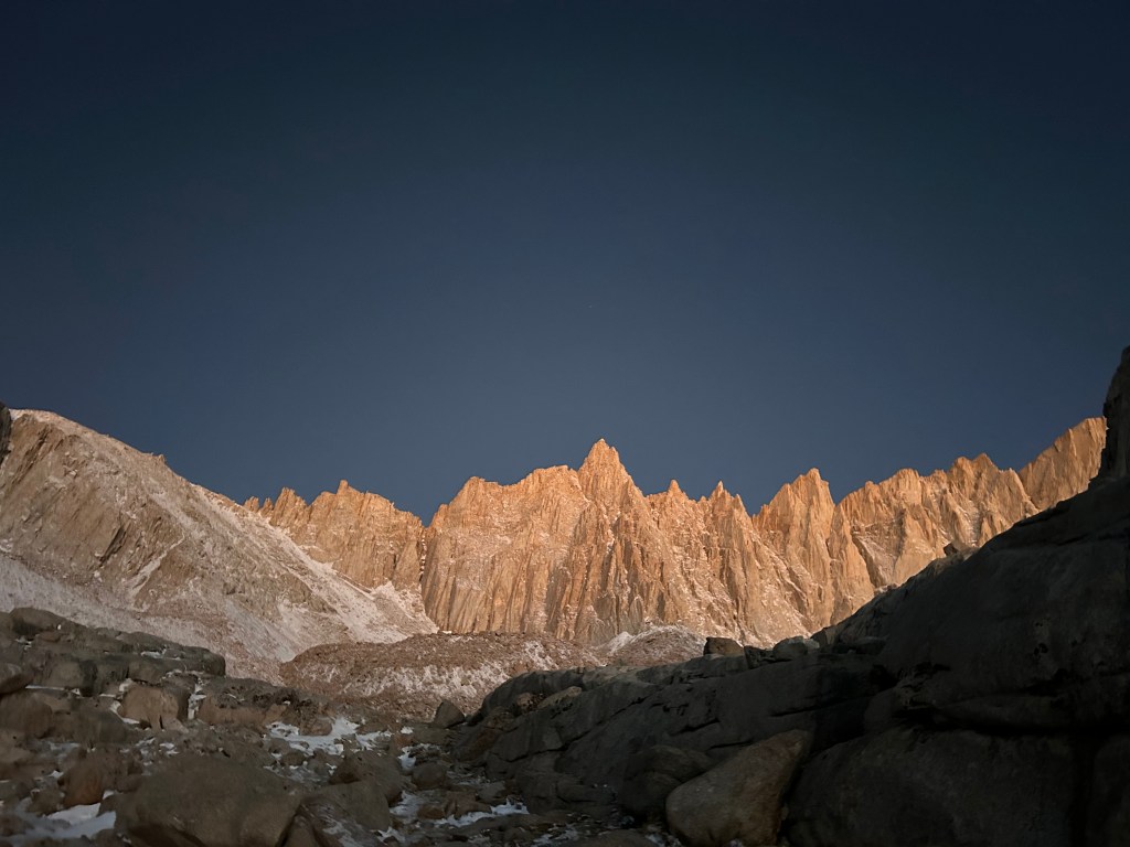
We reached Trail Camp around sunrise and got our first view of Mount Whitney.
The 99 Switchbacks (Not as Bad as They Sound)
The infamous “99 Switchbacks” section starts right after Trail Camp. It’s steep but very manageable, and not as bad as it looks and sounds on paper.
Poles and spikes were very helpful here, as the snow had accumulated and there were slippery areas.
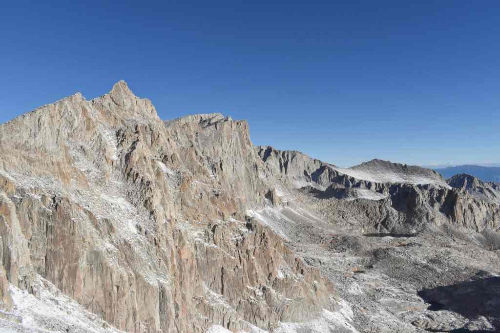
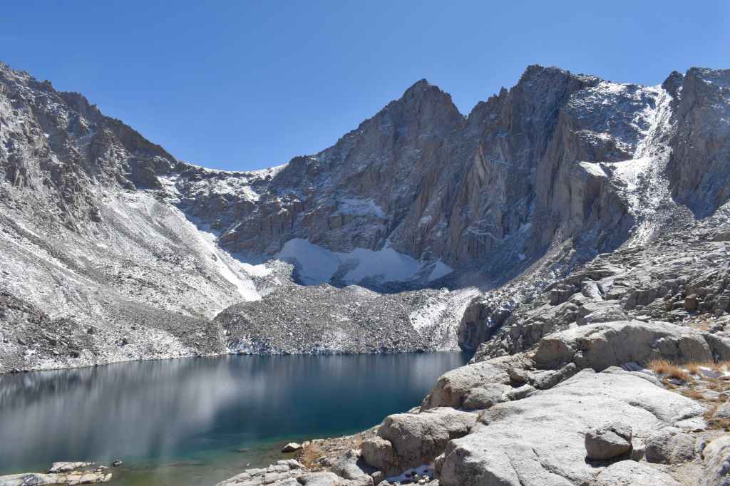
Trail Crest to Summit: Most Scenic Section
At the top of the switchbacks, we passed a sign for Sequoia National Park, marking the start of the spectacular ridge section leading to the summit.
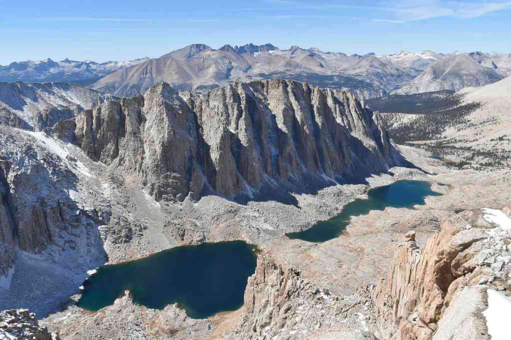
Along this ridge, the trail gets rockier and moves up and down alongside the mountains. There are constant views the entire time – dramatic granite peaks, Guitar Lake, and the alpine.
The final stretch leading up to the summit was the toughest, as you’re significantly above 14,000 feet, although thankfully it wasn’t terribly steep.
The Summit
I summitted around 10:30am. It wasn’t too crowded.
At the top, there was:
- A metal Mount Whitney summit sign
- A stone hut with a visitor logbook outside
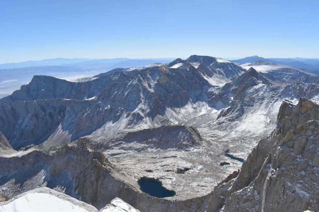
- Incredible 360° views across the Sierra Nevada
- An official (very worn down) elevation marker
The views are incredible in every direction. 10/10 worth it.
The Descent
The Trail Crest portion on the way back feels long and a bit demoralizing, with a few short but annoying uphill sections.
Descending the 99 switchbacks was much faster than going up, and having the snow and slush actually helped cushion my knees.
However, the worst part of the descent came after Trail Camp. The trail gets very rocky, hard on the knees, and difficult to find for a few miles before switching back to an easy dirt path for the last few miles.
There were also some beautiful lakes and streams to refill water from and hang out if you’re not in a rush to get down.
Gear, Food, and Water for a Mount Whitney Day Hike
Pack weight
- ~19 lb pack and a 2lb camera.
- Fun fact: There’s a luggage scale at the Whitney Portal trailhead so you can weigh your pack before you start hiking.
Water
- I drank about ~3 liters, started with ~3.5 liters. I brought electrolytes with me but didn’t use them.
- The water in my hydration valve froze during the ascent, so it was necessary to have a water bottle as backup.
- If you carry a water filter, there is plenty of potable water below Trail Camp where you can refill your water. There are no water sources above Trail Camp.
Food
- During the hike, I ate six peanut butter sandwiches and a handful of sour patch kids.
- My post-hike meal was a grilled chicken sandwich at Whitney Portal Store. It was expensive not super enjoyable despite the long hike – I’d recommend holding out on food until returning to Lone Pine, although I did hear the giant pancakes at Whitney Portal are pretty good.
Clothing for Mount Whitney in October
I wore layers almost the entire day since temps were freezing for most of the hike, but I delayered after the sun came up past Trail Camp.
- Base layer
- Merino wool mid-layer
- Fleece
- Thin puffer
- Columbia shell
- Two layers of pants
- Poncho in case of rain
- Beanie and gaiter
- Two pairs of gloves (thin and ski gloves) – both were necessary
Training and Acclimation for Mount Whitney
I spent the month before the hike in Denver (~5,000 ft) and did several 14’ers and high-altitude hikes to prepare:
14er Training Hikes
Mount Bierstadt
- Stats: 7.25 miles, 14,066 ft summit
- Mount Bierstadt is a great first 14’er or warm-up 14’er, as it’s relatively short and has relatively less gain. Starts relatively flat, makes a lot of gain towards the end, some scrambling near the summit.
Mount Elbert
- Stats: 9.75 miles, 14,438 ft summit
- Mount Elbert is the 2nd tallest peak in the contiguous U.S.
- It’s known for being a great Whitney training hike, as it mimics the non-technical slog of Whitney and spends significant time above 14,000 feet.
Other High-Altitude Training Hikes
Chief Mountain
- Stats: 3 miles, 11,712 ft summit
- Chief Mountain is a short, decently steep hike, fantastic for starting training. It’s only an hour drive away from Denver, so easy to reach for a quick hike before or after work. The views of the Rocky Mountains from the top are great.
Square Top Lakes
- Stats: 5 miles, 12,266 ft summit
- Square Top Lakes is a nice but muddy hike near Mount Bierstadt. The hike has very little tree cover and is great way to get to elevation without committing to a long hike.
- For additional training, you can add Square Top Mountain for a longer and more difficult hike that reaches 13,000+ ft.
Silver Dollar & Murray Lakes
- Stats: 4 miles, 12,212 ft summit
- Silver Dollar & Murray Lakes is another short but steep hike that reaches high elevation. It’s located near Square Top and Mount Bierstadt. The hike has great views of a few lakes and the surrounding mountains and bowls.
Chasm Lake
- Stats: 8.5 miles, 11,795 ft summit
- Chasm Lake is a longer hike with relatively gradual gain. It’s a good option for spending extended time at a decently high elevation.
- The hike is one of my favorites in Colorado and leads to a beautiful lake under the iconic Longs Peak (Colorado 14er).
Herman Gulch to Herman Lake
- Stats: 6.5 miles, 12,011 ft summit
- Herman Gulch to Herman Lake is a hike an hour’s drive away from Denver, with a couple of extended steep sections that are great for training.
- There are great mountain views throughout and a beautiful lake at the end. I twisted my ankle on some tree roots.
Final Acclimation Before Mount Whitney
Before Whitney, I spent two nights in Mammoth Lakes (~8,000 ft) to acclimate further (following the “sleep high” advice), and did a short bonus hike at around 10,000 ft to prepare.
Mount Whitney Logistics
Travel
- Flew into: Reno, Nevada
- Acclimation: Mammoth Lakes, California (2 nights)
- Day before the hike, drove to Lone Pine, California (town next to Whitney Portal trailhead area)
Permit
A permit is required to hike Mount Whitney between May 1 – November 1. Getting a permit requires entering the Mount Whitney lottery.
The lottery opens in February each year. I entered for several July–October weekends. Summer dates are typically more difficult to get. Walk-ups are not allowed, but it’s possible to find last-minute permits on the website when others cancel.
My permit was never checked by a ranger, but I did see a ranger hiking the trail.
Overall Thoughts: Is Day Hiking Mount Whitney Worth It?
Mount Whitney is incredibly beautiful and surprisingly gradual for a 14’er, but it’s still a slog of a day. It’s tough but 100% worth it.
- The uphill was long but steady and manageable and went faster than expected.
- The downhill was brutal – rocky, neverending, tough on the knees.
- The views were incredible from start to finish.
I’d love to come back to explore the Alabama Hills, spend more time in Mammoth Lakes and Yosemite, or hike other Sierra Nevada 14’ers once I gain more mountaineering experience.
